The 6th day of our trip started in Alaska, moved through Sausalito, CA, onward through Norway's fjords and ended in the alps of Switzerland...and on the 7th day we went to the moon.
 |
| volcanic cliffs just west of Hofn |
 |
| volcanic cliffs just north of Hofn |
Heading east to the coastal fishing village of Hofn (pronounced Hup) we visited some roadside glaciers (Heinabergsjokull where three glaciers meet, down a gravel road) and revisited the Jokulsarlon Glacier Lagoon which at 9:00 am was completely empty and looked entirely different then it did at 8:00 pm the night before. I've realized that about a lot of places...how dramatically changing weather and time of day influence the experience you have in Iceland. We'd heard about restaurants in Hofn serving delicious langoustine, arrived at Humarhofnin at lunchtime and Chad had a lunch of 6 full langoustine while I enjoyed just tails. (Pakkhus is another restaurant option). At about $70 a plate, it was a splurge, but langoustine had a unique soft, sweet, melt in your mouth texture different from lobster, but are small like very large shrimp. Served with assorted dipping sauces, salad (which you crave in Iceland) and of course hot bread and Icelandic butter, it was a very nice indulgence. The town is situated at the bottom tip of the southeast coast on a small peninsula that projects out into the ocean and is worth a short stop, particularly since its a good place to refuel and replenish in the large grocery store.

And then our trek turned north along the Eastern Fjords and everything changed again. At first the road parallels the twisting black sand beaches with black volcanos on both sides, and then you seem to be riding the crest of the black cliffs overlooking the ocean. The cliffs house nesting birds which soar in the strong winds, but unfortunately we didn't see the elusive puffin which nests in these cliffs during the spring and summer seasons before spending the fall and winter out to sea. You are traveling now on the east side of the massive Vatnojokull Ice Cap, so there are still glaciers on this side, too, mountains with snow and waterfalls galore, some of which you can easily access. Along the way, there are very small villages dotting the rugged coast, some with ferry service to Norway and to small offshore islands where puffins also nest.
 |
| volcanos and misty sky near Stokksnes...and the sun! |
 |
| inland view near Stokksnes |
 |
| black sand beach north of Stokksnes (where I found the bouy). |
 |
| Random, side of the road waterfall, Fossa...note the staggered green rock formations. |
 |
| typical coastal harbor |
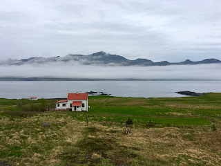
At a point, we left the Ring Road which veered slightly inland and we traveled on Hwy 96, the paved coastal road which connects the coastal towns along the rugged fjords jutting out into the ocean. This is when the weather turned bad...pouring rain at first and then this mist that descended down over the fjords like a snowless blizzard. A very wet and cold, but not liquid, mist which created an eerie feel. As we merged back into the Ring Road and headed slightly inland away from the ocean, the snow-covered mountains and fjords had this misty haze hanging half way up and it was beautiful.
 |
| typical house along the fjords |
 |
Fjord near Reydarfjordur
|
We visited the small coastal town Reydarfjordur where the show Fortitude is filmed and decided that the 17 mile trek into gorgeous, artsy Seydisfjordur seatown was not an option due to the weather which would obscure the views of the fjord where it is situated. (Apparently this town only sees the sun for a few months a year as it sits low behind the mountainous fjord much of the year.) A beautiful waterfall hike to Litlalanesfoos and its uphill neighbor, Hengifoss, was also planned, but with the wet weather, we decided it could be slippery and cold.
We arrived into Egilsstadir around 6:00 pm and had plenty of eating and grocery options, but were tired from the long drive, had eaten a massive lunch and the weather was oppressive, so we bunkered down in the Skipalaekur Guesthouse for the night eating cheese and crackers for dinner. This place was very basic and didn't include breakfast for us, but was clean and comfortable, and when I was looking at lodging options, most of the choices seemed very basic in this region.
The next morning we began our trek west to Iceland's northern, geothermic region. This is when the place really started to look like the moon. Vast fields of black sand, with rocks randomly scattered, and in the very far distance, volcanos, mountains, mist and scary sky looming. This lava vista was entirely different from the green moss covered lava rocks we had seen in the south.
There are two roads to Dettifoss, Europe's largest waterfall. The eastern route 864 is not clearly marked, nor is it paved (and I don't think Iceland is promoting access to the falls from the east side because looking over to that side, it doesn't look tourist-friendly, but it is possible in the right car and right season to access the falls from the east). The western route 862 is a good paved road heading north, with a turnoff to the parking area for Dettifoss and its upstream neighbor Selfoss. (It looks like there are plans to pave 862 north of Dettifoss towards coastal Husavik to create an easy access from the south to Asbyrgi Canyon. The road was unpaved and closed at the end of May, and must still be an F-road, so access to Asbyrgi Canyon is from the north only, so it was off the agenda.)
Dettisfoss is spectacular with many viewing platforms to view from various perspectives.
 |
| looking from Selfoss back towards Dettifoss |
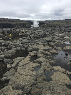
But to me, more spectacular is its neighbor Selfoss, with access over black lava rocks which are stepping stones over the "calmer" side of the river before it flows over the canyon. Selfoss is a horseshoe shaped waterfall seemingly at the end of a canyon, with smaller waterfalls coming off the sides as you approach. The water has a greenish blue milky color to it and if you are very brave, you can literally almost walk to the very edge where the massive cascade begins.
 |
| stepping over massive lava rocks to approach Selfoss |
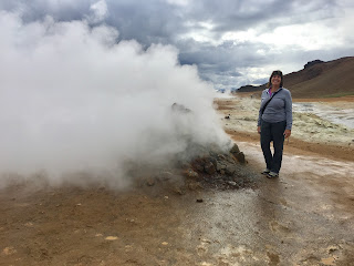
After a few hours at the falls we continued west to Lake Myvatn (Me-vat). Hverir, the geothermal region with its sunset colors and boiling pots of mud and fumaroles with hot steam blowing. I believe there is a hike up the mountain that overlooks the geothermal site (maybe to Hverfill?)
 |
| what about this sky? |
A short hike up to the crater of the dormant black Hverfell volcano, with views over the region...
A visit to Grjotagja cave from GOT accessible by car or 2 different 2-km hikes either from Hverfell Crater or from the Ring Road, and a peek at the massive rock fissure above it.
We didn't visit Myvatn Nature Baths, supposedly a less touristy, less costly version of the Blue Lagoon, we cut short a hike to Krafla Crater and forgot to visit the lava formations at Dimmuburgir.
We did have a delicious late lunch at the Cowshed at Vogafjos (also a guesthouse) where you eat with views of grazing cows and cows in the barn and eat very fresh, organic food. We had smoked lox prepared 2 ways, smoked lamb (which was a little too raw for me), geysir bread cooked in the earth and lots of dips and spreads and it was a very unique experience. The lamb shanks looked delicious and they had a skyr dessert which sounded tasty. I think they are supposed to have a good skyr dessert, too which we didn't have.
 |
lunch at Vogafjos; smoked lamb, blueberry dipping sauce, dill sauce...YUM
For nights 6 and 7 we stayed at Ondolfsstadir Farm B&B in nearby Lauger which served a nice breakfast in a clean comfortable room with a pleasant host. We stayed 2 nights here, but you could easily stay only one night and head towards the west and the Snaefellsness Peninsula and stay closer to your next destination. After Akureyri, the towns are few and far between here and you will need to make sure you have reservations and plenty of gas. But even staying near Akureyri puts you 45 minutes closer. Also, plan your access into Snaefellsness, as the northern route is a gravel road. Accessible, but a little bumpy, but with amazing views. Some suggested access through the paved southern access which is more mileage but possibly faster. |


No comments:
Post a Comment